Sept 4 –
Sept 12 2013
I left MO on Sept 4th. I would have made many more stops on the way to CA, but I needed to arrive before Sept 14th to attend the engagement party of a couple of very close friends. I decided to take US 70 west because I had not traveled on that highway across the Rocky Mountains before. I must say I’m not sure I would take that route again. There are several 6% and 7% grades that continue for several miles. My poor truck was struggling so hard at the top of the first steep grade I had to pull over at the summit and let the engine cool. I have crossed the Rockies on US 80 and never had that problem. I checked the map and realized I would be passing very close to Arches and Canyonlands National Parks so I decided to spend a day in each park. I stayed in a RV park in Moab UT as it was almost 100 degrees when I arrived and I needed an electrical hookup to run my AC. As luck would have it the next two days I spent in the parks it was overcast and rainy. At least it was cooler. Because of the weather conditions the colors in the photographs are not as vivid as they would be in direct sunlight, but it was still a beautiful place, even in the rain.
I left MO on Sept 4th. I would have made many more stops on the way to CA, but I needed to arrive before Sept 14th to attend the engagement party of a couple of very close friends. I decided to take US 70 west because I had not traveled on that highway across the Rocky Mountains before. I must say I’m not sure I would take that route again. There are several 6% and 7% grades that continue for several miles. My poor truck was struggling so hard at the top of the first steep grade I had to pull over at the summit and let the engine cool. I have crossed the Rockies on US 80 and never had that problem. I checked the map and realized I would be passing very close to Arches and Canyonlands National Parks so I decided to spend a day in each park. I stayed in a RV park in Moab UT as it was almost 100 degrees when I arrived and I needed an electrical hookup to run my AC. As luck would have it the next two days I spent in the parks it was overcast and rainy. At least it was cooler. Because of the weather conditions the colors in the photographs are not as vivid as they would be in direct sunlight, but it was still a beautiful place, even in the rain.
The first park I visited was Canyonlands NP.
 |
| I arrived at Canyonlands NP just in time for sunrise |
 |
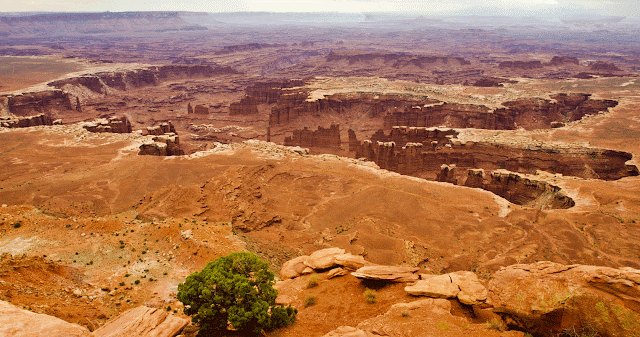
| View from the Green River Overlook - Canyonlands NP UT |
 |
| The ranger gave a talk about the park road system being established by the Uranium mining companies that were in the area before it became a national park. |
 |
| Two rock formations named the Monitor and Merramac after the two civil war battleships. |
 |
| I thought this rock formation looked like a turtle. I like turtles so I took its picture. |
 |
| This is from an overlook called the Grand View. It truly was a grand view. |
 |
| The rocks on this wall were beautiful shades of red. You can see the lighting conditions I had to work with. |
 |
| Buck Canyon overlook - Canyonlands NP UT |
On the second day I visited Arches NP were I encountered even more rain. I did a lot of sitting and waiting for breaks in between showers. Thunderstorms would have been better than this constant drizzle and overcast skies.
 |
| On the Park Ave trail - Arches NP UT |
 |
| Double Arch - Arches NP UT |
 |
| The area around Double Arch - Arches NP UT |
 |
| North Window - Arches NP UT You can get a sense of size by comparing the opening to the people in the photo. |
 |
| South Window - Arches NP UT |
 |
| Sand Dune Arch - Arches NP UT |
 |
| Rock formation near the visitor center - Arches NP UT |
 |
| Wet Cliffs - Arches NP UT |
I took a side trip down Utah highway 128 that runs through a canyon that was carved by the Colorado River. If any one finds themselves in the Moab UT area I highly recommend this drive, but you night not want to take a big rig as it is a very narrow road with constant road repairs being made. There are BLM campgrounds along the way, but only the smallest of campers will fit. There were a few class C's, but I wouldn't even take my trailer into most of them as there is no place to turn around if the campground is full. The sites are best suited for tents and class B rigs.
 |
| Upper Colorado River along Utah Highway 128 near Moab UT |
 |
| View of cliffs and Colorado River from Utah highway 128 near Moab UT. |
 |
| Canyon wall along Utah highway 128 near Moab UT. |
 |
| Boat on the Colorado river along highway 128 near Moab UT |
No comments:
Post a Comment